
具体描述
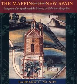
Although Cortes conquered the Aztec empire in 1521, imperial Spain knew little about the Mexican territory under its control when Philip II acceded to the throne in 1556. As part of a vast project to learn about its territories in the New World, Spain commissioned a survey - the Relaciones Geograficas - of Spanish officials in Mexico between 1578 and 1584, as king for local maps as well as descriptions of local resources, history, and geography. Offering a contemporary record of what sixteenth-century Mexico looked like, the sixty-nine manuscript maps from this survey also highlight the gulf between colonial and indigenous conceptions of Mexico. In this text Barbara Mundy illuminates the complex cultural negotiations that colonists and indigenes undertook in mapping the colony. She explains the Amerindian and Spanish traditions represented in these early colonial maps, and traces the gradual reshaping of indigenous world views in the wake of colonization.
作者简介
目录信息
读后感
评分
评分
评分
评分
用户评价
相关图书


本站所有内容均为互联网搜索引擎提供的公开搜索信息,本站不存储任何数据与内容,任何内容与数据均与本站无关,如有需要请联系相关搜索引擎包括但不限于百度,google,bing,sogou 等
© 2026 onlinetoolsland.com All Rights Reserved. 本本书屋 版权所有